UAVGNSS
Introduction to UAV GNSS
UAV GNSS is a critical technology that enables unmanned aerial vehicles to navigate accurately and operate autonomously. Modern drones rely heavily on GNSS to determine their precise position, altitude, speed, and direction during flight. Without UAV GNSS, advanced features such as waypoint navigation, automated missions, and return-to-home functions would not be possible. As drone usage continues to expand across commercial and industrial sectors, the importance of reliable and accurate GNSS systems has increased significantly. UAV GNSS acts as the foundation for safe, efficient, and intelligent drone operations in both simple and complex environments.
What Is UAV GNSS?
UAV GNSS refers to the use of Global Navigation Satellite System technology within unmanned aerial vehicles. It allows drones to receive signals from satellite constellations such as GPS, GLONASS, Galileo, and BeiDou. These signals help the UAV calculate its real-time geographic position and timing information. UAV GNSS is not limited to basic navigation; it also supports flight stability, altitude control, and mission planning. Today, most professional drones are equipped with multi-constellation GNSS receivers to improve accuracy and reliability, making UAV GNSS an essential component of modern drone systems.
How UAV GNSS Works
UAV GNSS operates using a positioning method called trilateration. The GNSS receiver on the drone collects signals from at least four satellites simultaneously. Each satellite transmits a time-coded signal, which the receiver uses to calculate the distance between the satellite and the UAV. By combining these distances, the system determines the drone’s exact three-dimensional position. This information is continuously sent to the flight controller, which adjusts the motors and control surfaces. Advanced UAV GNSS systems use multiple frequencies and constellations to ensure stable and accurate positioning in real time.
Importance of UAV GNSS in Drone Navigation
UAV GNSS plays a central role in drone navigation and flight control. Accurate GNSS data allows drones to maintain stable flight, follow predefined routes, and hover precisely at specific locations. Safety features such as geofencing, return-to-home, and emergency landing depend entirely on reliable UAV GNSS signals. In commercial drone operations, regulatory compliance often requires GNSS-based tracking and positioning. Without UAV GNSS, autonomous flight would be extremely limited, increasing the risk of navigation errors and accidents. Therefore, GNSS is essential for both operational efficiency and flight safety.
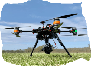
Applications of UAV GNSS in Agriculture
In the agriculture sector, UAV GNSS is widely used for precision farming applications. Drones equipped with GNSS technology can perform crop monitoring, field mapping, and targeted spraying with high accuracy. Precise positioning allows UAVs to fly consistent paths, reducing overlap and minimizing waste of fertilizers and pesticides. Advanced RTK-based UAV GNSS systems provide centimeter-level accuracy, which is especially useful for row-by-row crop analysis. By using UAV GNSS, farmers can make data-driven decisions, improve productivity, and reduce operational costs while promoting sustainable farming practices.
UAV GNSS in Surveying and Mapping
UAV GNSS has revolutionized surveying and mapping by offering faster and more cost-effective alternatives to traditional methods. GNSS-enabled drones can capture high-resolution aerial data for land surveys, construction planning, and infrastructure inspection. RTK and PPK UAV GNSS technologies allow surveyors to achieve highly accurate geospatial data without extensive ground control points. This improves efficiency and reduces project timelines. UAV GNSS is now widely used in mining, urban planning, and environmental monitoring, making it an indispensable tool for modern geospatial applications.
Accuracy Levels of UAV GNSS
Different UAV GNSS systems offer varying levels of accuracy depending on the technology used. Standard GNSS systems typically provide accuracy within one to three meters, which is suitable for basic drone operations. Differential GNSS and SBAS systems improve accuracy to sub-meter levels. For high-precision applications, RTK and PPK UAV GNSS systems deliver centimeter-level accuracy. Choosing the appropriate accuracy level depends on the application requirements, budget, and operational complexity. Higher accuracy systems provide better results but require additional infrastructure and technical expertise.
Challenges Faced by UAV GNSS
Despite its advantages, UAV GNSS faces several challenges that can affect performance. Signal interference from buildings, terrain, and electronic devices can reduce accuracy. GNSS jamming and spoofing pose serious security risks, especially for critical operations. Multipath errors caused by signal reflections can also distort positioning data. Additionally, GNSS performance is limited in areas with poor satellite visibility, such as dense forests or urban canyons. To address these challenges, UAV systems often integrate additional sensors and advanced algorithms to maintain reliable navigation.
Enhancing UAV GNSS Performance
To improve UAV GNSS performance, modern drones use sensor fusion techniques that combine GNSS data with inertial measurement units, vision sensors, and LiDAR. Multi-constellation and multi-frequency GNSS receivers increase satellite availability and accuracy. Anti-jamming and anti-spoofing technologies enhance security and reliability in challenging environments. Correction services such as RTK networks and precise point positioning further improve accuracy. These advancements allow UAV GNSS systems to perform effectively even in complex or degraded signal conditions.
Future of UAV GNSS Technology
The future of UAV GNSS technology is closely tied to advancements in satellite navigation and autonomous systems. Next-generation GNSS signals will offer improved accuracy, faster signal acquisition, and better resistance to interference. Integration with artificial intelligence and 5G connectivity will enable smarter and more responsive drone operations. As applications such as drone delivery and urban air mobility continue to grow, high-precision UAV GNSS will become even more critical. This technology will remain a key driver of innovation in the global drone industry.